The history of agile software development is not what most people think, and is nothing like the story pushed by most Agile Evangelists.
Our latest publication A Brief History of Agile shows that from the beginning of large system software development the people managing the software engineering understood the need for prototyping and iterative and incremental development. This approach has always been part of the way good software is developed.
The environment the authors of the early papers referenced and linked in the article were operating in, satellite software and ‘cold-war’ control systems, plus the limitations of the computers they were working on, did require a focus on testing and documentation – it’s too late for a bug-fix once WW3 has started….. But this is no different to modern day control systems development where people’s lives are at stake. Otherwise, nothing much has changed, good software is built incrementally, and tested progressively,
The side-track into ‘waterfall’ seems to have bee started by people with a focus on requirements management and configuration management, both approached from a document heavy bureaucratic perspective. Add the desire of middle-management for the illusion of control and you get waterfall imposed on software developers by people who knew little about the development of large software systems. As predicted in 1970, ‘doing waterfall’ doubles to cost of software development. The fact waterfall survives in some organisations through to the present time is a factor of culture and the desire for control, even if it is an illusion.
The message from history, echoed in the Agile Manifesto, is you need to tailor the documentation, discipline, and control processes, to meet the requirements of the project. Developing a simple website with easy access to fix issues is very different to developing the control systems for a satellite that is intended to work for years, millions of miles from earth.
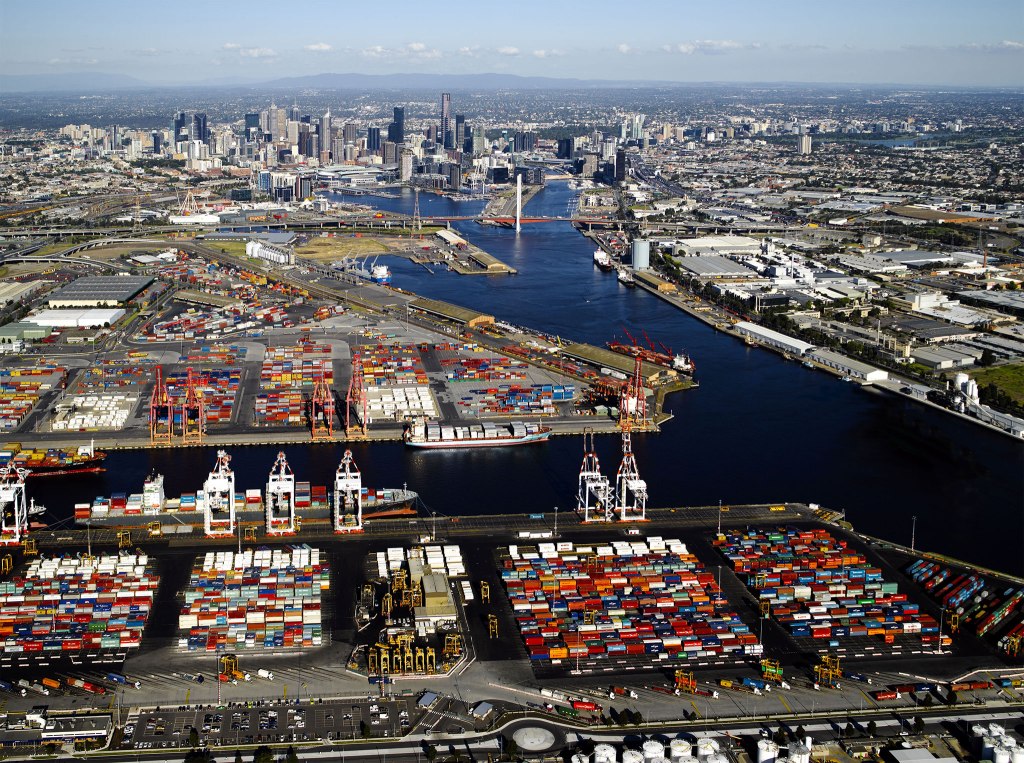
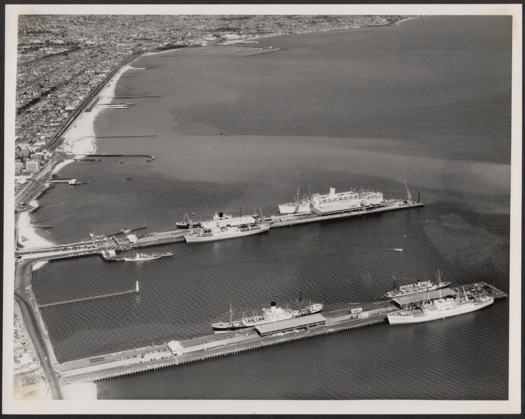
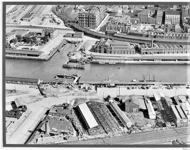
The Port of Melbourne is the largest port for containerized and general cargo in Australia. Anyone visiting the port, or Melbourne generally, would think the Yarra River must have been a useful harbor at the time of settlement, and the various docks were built to enhance this natural asset. Modern maps, and the view out to Port Philip Bay reinforce this concept.
Aerial view of the Port of Melbourne
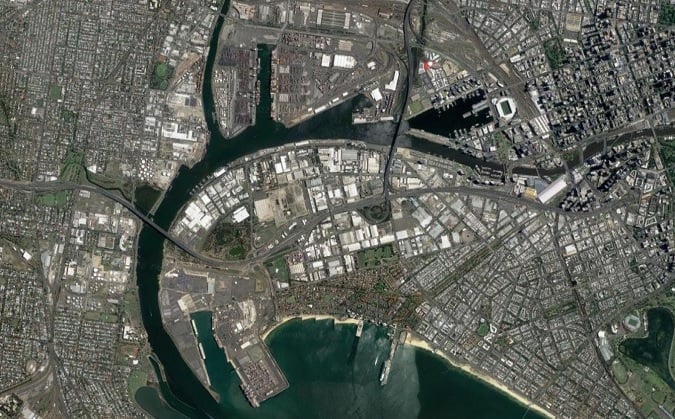
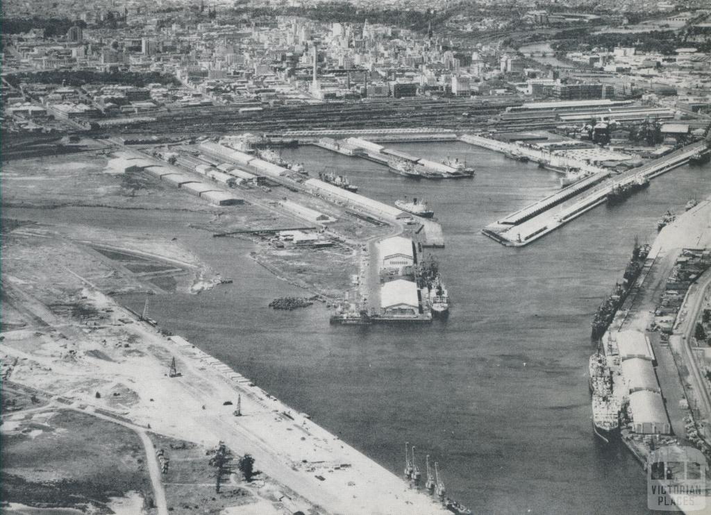
View to the South West of the port and bay.
The truth is very different, almost everything shown in the pictures above is man made.
Settlement
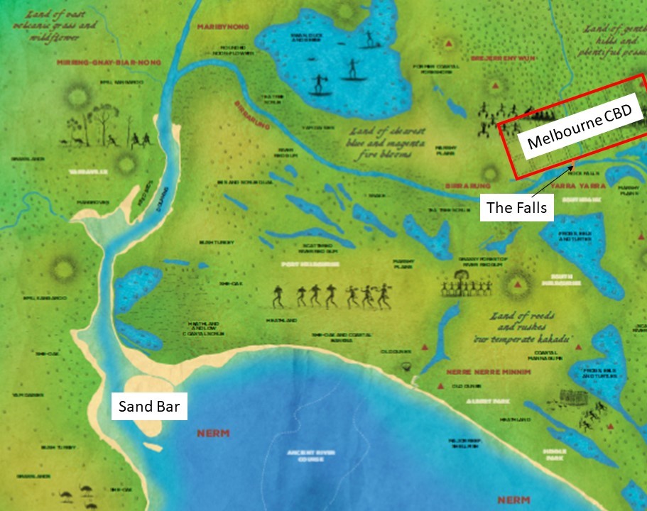
The settlement of Melbourne started in 1835. To put this date in context, it is 20 years after the Battle of Waterloo and 2 years before the coronation of Queen Victoria[1]. The original settlement was located in the area of the current day CBD. This site was chosen for its access to fresh water from the stream running through the site, rather than its potential as a port.
An underwater sand bar at the entrance of the Yarra River ruled out the entry of vessels drawing more than about nine feet of water and access up river was blocked at ‘The Falls’, a rock bar running across the river which was used as a crossing point by the local Aboriginal peoples.
This limited access meant ships arriving from overseas had to drop anchor in Hobson’s Bay, or moor at the Sandridge (Port Melbourne) Pier. Passengers and goods then had to walk, use carts, or be transshipped up the river in smaller vessels or ‘lighters’ as they were called. Costs were excessive! It has been recorded that it cost 30 shillings per ton (half the entire freight costs for the voyage from England) to have goods taken the eight miles from sea to city.
The discovery of gold in 1850 exacerbated the problems of the port. In just one week in 1853 nearly 4000 passengers from 138 ships arrived in Hobson’s Bay and in 1858 the average delay moving goods from the port into the city was three weeks.
The initial solution to this problem was the construction in 1854 of the first steam railway in Australia from piers built at Sandridge (now the suburb of Port Melbourne) to the city this railway is discussed in The First Steam Powered Railway in Australia, but a better solution was needed for cargo.
Developing the Port of Melbourne – 1839 to 1877
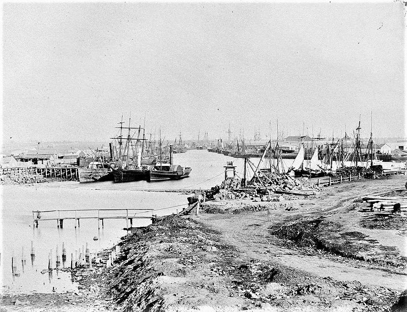
The Yarra River was progressively improved to facilitate trade. Jetties were built along the banks of the river from 1839 onwards funded by wharfage charges. This 1857 photograph shows the wharfs downstream from ‘The Falls’.
1857 – Yarra River downstream from ‘The Falls’
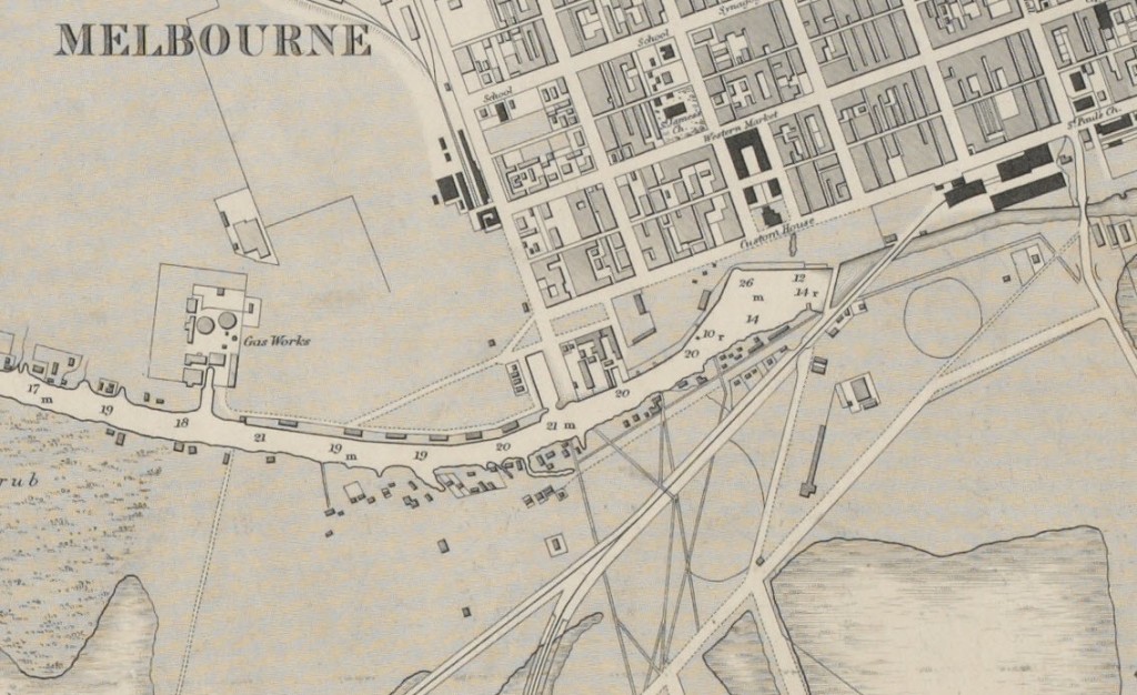
The 1864 map of Melbourne shows the limitations outlined above were still limiting the development of Melbourne despite the massive influx of money from the Victorian gold rush. The Falls effectively dammed the river causing major flooding and the restrictions caused by the swamps bends and shoals in the Yarra restricted trade.
To overcome the problems, the Melbourne Harbor Trust was formed in 1877 and engaged English engineer, Sir John Coode to recommend solutions.
Starting in 1879 Sir John Coode made three key recommendations: – the development of a canal to improve access for ships, – the demolition of The Falls to reduce flooding, and – the deepening of the narrow entrance to Port Phillip Bay from the ocean.
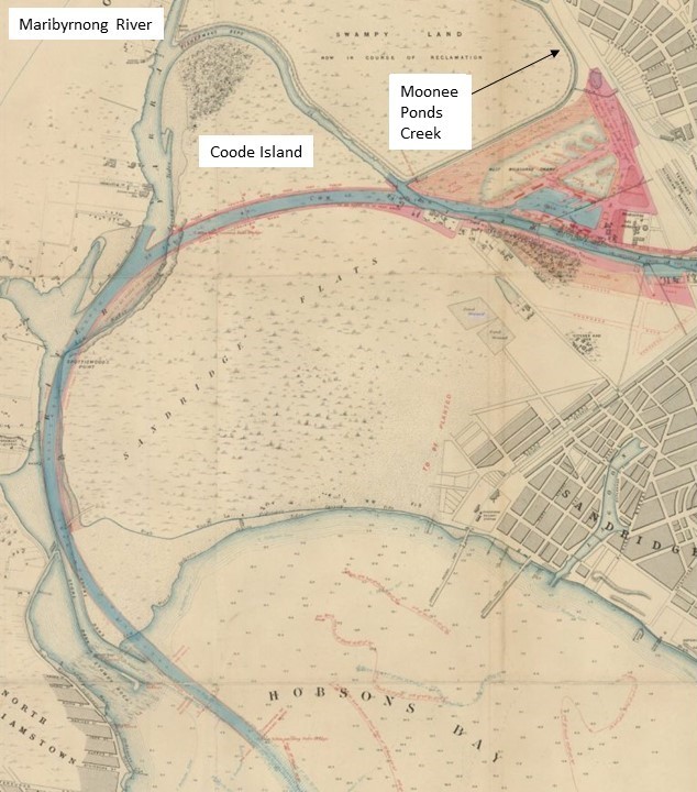
Based on Sir John’s recommendation, the course of the lower Yarra’s was significantly altered. This visionary feat of engineering involved 2,000 workers for 20 years. The proposal not only significantly shortened travel time up the river for ships, but also created Victoria Harbour and Victoria Dock.
Plan for Coode Canal and Victoria Dock (the dock was changed to a single body of water later)
The original wide loop in the river was eliminated through the construction of the 1.5 km Coode Canal which opened in 1886, and West Melbourne Dock (now Victoria Dock) opened to shipping in 1893. The canal created Coode Island and caused the shallow, narrow and winding Fishermans Bend to be cut off along with other sections of the river including Humbug Reach and the original junction with the Maribyrnong River. The Coode Canal was deepened to 25 feet and widened from 100 to 145 feet in 1902.
The plan to remove ‘The Falls’ involved clearing the reef to a uniform depth of 15 feet 6 inches, at an estimate cost of £20,000. The demolition was complete by 1883, having been funded by a combination of the Victorian Government and the Harbour Trust. The reduction in flooding caused by the improved river flows converted flood plains and swamps into dry land, encouraging the development of South Melbourne discussed in The evolution of South Melbourne. The lake in Albert Park is all that remains of the freshwater lagoons and seasonal swamps South of the Yarra.
The Rip at Port Phillip Heads was also deepened in 1883 using explosives.
Developing the Port of Melbourne – 1902 onward.
The piers at Sandridge (Port Melbourne) continued to be important, but mainly for passengers. A new pier, built to the west of Railway Pier, opened in 1916, called the New Railway Pier. This was renamed Prince’s Pier in 1921. These piers were important locations for the departure and return of troops to the Boer War in South Africa and WW1 &2, as well as the arrival of many thousands of migrants after WW2.
The Piers at Port Melbourne c1950.
The current Station Pier, which replaced the original Railway Pier, was built between 1922 and 1930 and remains the primary passenger arrival point in Melbourne with cruise ships visiting throughout summer. Princes Pier has been demolished.
Meanwhile, most cargo shipments were handled by the Victoria Dock, and by 1908 it was handling ninety per cent of Victoria’s imports. In 1914 its capacity was enlarged by the addition of a central pier and in 1925 the entrance was widened. But with rapidly increasing imports and exports further renovation and development was needed. Also, as ships increased in size there was a need for larger wharves and deeper berths to accommodate them.
The growth of the city also encroached on the Eastern end of the docks. The construction of the Spencer Street Bridge in 1927-28 meant that all port traffic had to be handled further downstream, foreshadowing the need for even more docks, and the expansion of the port towards the West and the bay.
Construction of Spencer St. Bridge
Port development at Coode Island in 1958
To overcome these challenges, the docks spread to the West, and no cover all of the land between the land from Moonee Ponds Creek to the Maribyrnong River, totally absorbing Coode Island.
The original Victoria Dock and the adjacent North Wharf on the river continued to play a vital role, handling up to half of the Port of Melbourne’s trade until the shift to containerisation and then the construction of the Bolte Bridge in 1999, made the old port facilities redundant. From 2000 the Victoria Docks became Docklands, and were revitalised as commercial and residential areas, while the Port of Melbourne continues to expand downstream.
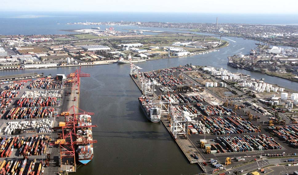
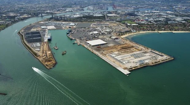
The last major expansion of the port was the construction of Webb Dock at the mouth of the Yarra River in 1960.
Webb dock at the mouth of the Yarra
Improvements in both wharf-side and land-side facilities continue, but despite all of these improvements, the Port of Melbourne is approaching capacity, the next developments are not far off but need political decisions on the location, either in Port Phillip Bay or Westernport Bay to allow the next transformation to start.
Footnote on the names
The rock bar called ‘The Falls’ in this post was called Yarro- Yarro meaning “waterfall or ever flowing” by the local peoples. The river was known as the Birrarung by the Wurundjeri people. The first settlers confused the names and called the river Yarra.
The , Yarro Yarro Falls were important to the local Aboriginal tribes, the Woiwurrung and the Boonerwrung, who used it as a crossing point between their lands, in order to negotiate trade and marriages. This was the only means of crossing the Yarra River until ferries and punts began operating c 1838. The first bridge was constructed c 1845, a little further upstream, at the location very near what is now known as the ‘Princes Bridge’.
As part of the research underpinning our series of articles on the history of railways (and the people and projects that created them), we identified the Diolkos (built in the 6th century BCE) as probably the first purpose built railway used to move commercial ships overland across the Isthmus of Corinth in Greece; see: /2023/04/17/the-diolkos-the-first-truly-commercial-project/
While the Diolkos’ place in the history of railways (or more accurately guided trolley ways) is not challenged, it seems the innovative approach used by the Corinthians was based on synthesis and elaboration rather than a ‘Eureka’ moment. As this post demonstrates, the use of a man-made structure designed to facilitate the movement of ships across land predates the Diolkos by more than 1000 years. Were the Greeks aware of these earlier developments? Was the Diolkos the result of an inspirational insight, or, as it appears the result of synthesizing a number of ideas from diverse sources to solve a novel problem?
Egypt during the Middle Kingdom
The complex history of the relationship between Ancient Egypt and Nubia (modern day Sudan) goes back millennia and is dominated by wars, conquests (in both directions), and trade; with the Nile being central to all these activities. However, in the ‘border’ region between Egypt and Nubia and extending upstream (South) the flow of the Nile is disrupted by a series of cataracts, the Second (or Great) Cataract being the most challenging for navigation.
The period this post focuses on is during the Middle Kingdom, when Egypt conquered the Nile Vally well to the South of the Second Cataract and built a series of massive forts to control both the land and the trade on the Nile. Goods from Upper Nubia and beyond were moved by boat on the Nile, including ebony, ivory, spices, exotic fruit, live animals, and skins, as well as gold, diorite, and other minerals from various mines.
During the reign of Senusret III (c1878-1841 BCE) great importance was placed on Lower Nubia. He established a separate administration for the Head of the South, and a canal was rebuilt around the First Cataract at Aswan enabling easier access for troops and trading vessels to reach as far as Buhen and the Second Cataract.
Getting around the Second Cataract was more difficult.
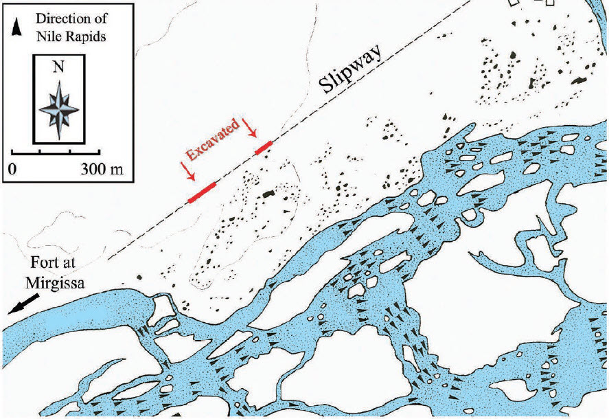
Fort Mirgissa
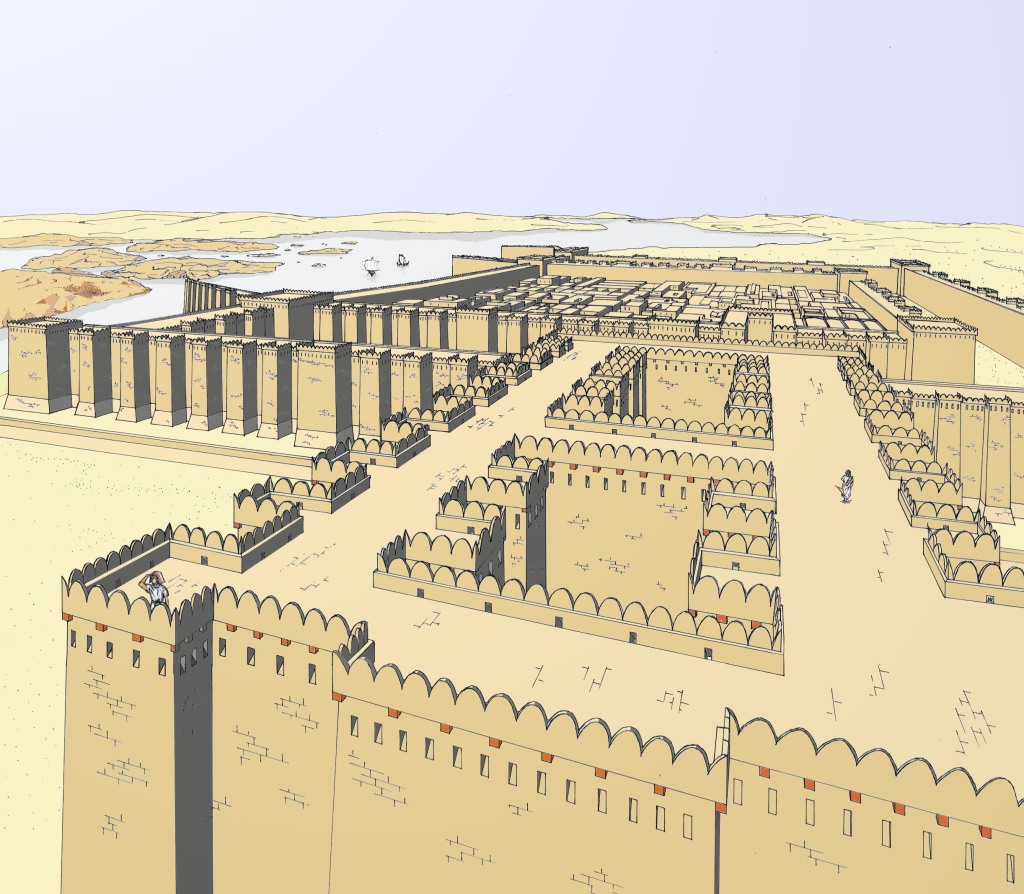
The Fort at Mirgissa was the largest of eleven Forts built by Pharaoh Senusret III during Egypt’s 12th Dynasty between the second and third cataracts. It was strategically placed above the cataract to control the River Traffic from the North, collecting revenues and taxes from all traders. Placed in the Western Wadi, the fort grew to 40,000 sq. meters. It was made of 10-meter-high mudbrick walls which were doubled to form a 6-meter thick outer and 6-meter-thick inner protective skin to the Fort, it had 12-meter-high square corner towers and numerous bastions for further protection.
After its construction, the fort also protected the harbour at the Northen end of Boat Slipway that run from the Nile below the cataract. Given that neither trade, exploration, nor war wait for the annual high waters needed for relatively safe navigation through the cataract, building the slipway to ensure safe portage was a prudent investment, of potentially great strategic advantage. The labor and resources invested to construct such an elaborate portage certainly indicates the significance of the traffic.
The Mirgissa slipway
The Mirgissa slipway is the only known example of its type. Conceived as a ‘boat road’, and constructed to avoid the least navigable portion of the Second Cataract, this structure allowed shipping movements all year. The slipway may have been built before the fort (the adjacent town is much older), and was used at least as late as the reign of Amenemhat III and possibly into the New Kingdom, a span of some 300 years.
As mentioned, the southern (upstream) end of the slipway was in close proximity to the fort of Mirgissa (but which came first is an open question), while its northern end may have been at Matugaor Abu Sir. This means the slipway ran straight for no less than 1.5 and perhaps as much as 4 km.
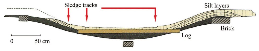
The slipway had a support structure of mudbricks, packed mud, and lateral wooden ties ‘rather like a railroad’, but remained low enough to benefit from the wetness of the silt to allow the boats to navigate the Slipway more easily sliding on the wet mud and timbers.
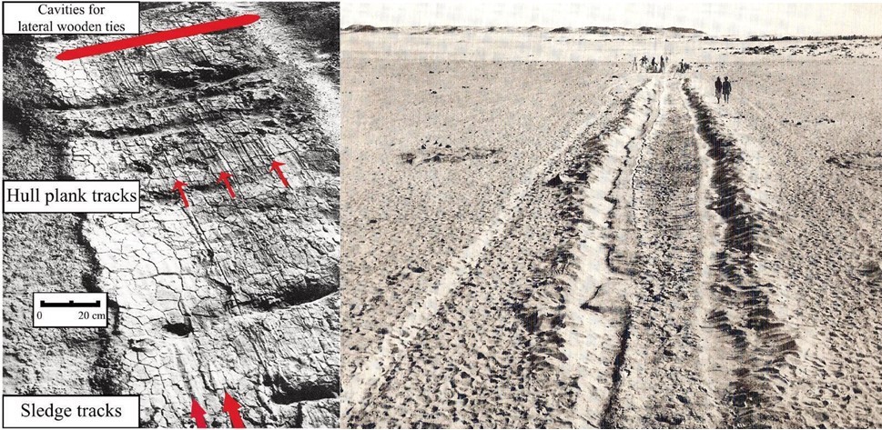
The slipway is approximately 3m wide, more than enough to accommodate the maximum beam (width) of the Twelfth Dynasty Dahshur boats (2.15 – 2.43 m) and would provide ample clearance for the width of a sledge. Both boat hull marks, and sledge tracks are evident on the excavated section of the slipway, these last travels baked into the watered silt road:
Why the portage stopped being used is unclear, the Second Cataract remained a major shipping hazard until submerged under the waters of Lake Nubia, created by the Aswan High Dam some 3,500 years later.
Conclusion
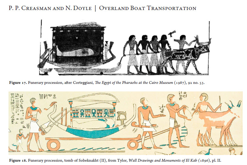
The correct answer to the question posed at the start of this article is unknowable. While the Diolkos may have been a parallel development with no outside influence, we know the Ancient Greeks and Egyptians traded across the Mediterranean and ideas travel with trade. We also know the Ancient Egyptians used both sledges and wheeled carts to move boats across land as part of their funeral rites and there is evidence of carved ruts being used to guide 4-wheeled carts in Malta well before the Diolkos was built.
What is not knowable is if Greek merchants or travelers made the journey up the Nile in the time of the Middle Kingdom and/or if the idea of man-made portages had wider currency and were a normal concept at the time.
From our perspective, there seems to be very few truly original ideas. Synthesis and elaboration are two of the key components of most innovation and there are very few completely original ideas. For more on innovation see: https://mosaicprojects.com.au/PMKI-PBK-005.php#Process3
Primary Refences:
Overland Boat Transportation During the Pharaonic Period: Archaeology and Iconography. Pearce Paul Creasman, Laboratory of Tree-Ring Research, University of Arizona Noreen Doyle, Institute of Maritime Research and Discovery Journal of Ancient Egyptian Interconnections | http://jaei.library.arizona.edu | Vol. 2:3, 2010 | 14–30
Canal construction is an interesting branch of both engineering and project management:
From the engineering perspective, planning a route that works (water flows in the right direction at the right speed), retaining the water within the canal, and overcoming natural obstacles indicates the need for a degree of design sophistication.
From a management perspective organising the 100s, or 1000s of people needed for the work and ensuring the work is done correctly is a significant exercise in organisation, logistics and control. As with most early projects, there’s scant information on how this was accomplished, but the results are self-evident.
Canals have been excavated and used for drainage and irrigation for thousands of years. But for most of this time, the use of canals was restricted to relatively flat areas with good water supply. It was the advances in technology in the Middle Ages that allowed canals and navigations to overcome the problem of hills, resulting in canals becoming a major form of transport. The First Canals is the final paper in a series looking at early transport projects.
The full set of papers in this series are:
The First Canals. This article looks at the early development of canals across the world from 4000 BCE through to the European medieval canal revival between the 12th and 16th centuries.
Early Canals, The Evolution of the Technology. Canals have been excavated for drainage and irrigation for thousands of years and once built, the larger of the canals were undoubtedly used for trade. However, for several thousand years canals were restricted to areas where the land was relatively flat. This article looks at the development of the technologies that allowed canals to traverse hills and valleys.
Early Canal Projects in the UK. Until the introduction of efficient steam-powered railways, canals were the driving force behind the industrial revolution in Britain. This paper looks at the development of canals in the UK from Roman times through to the start of the ‘canal mania’ in the 1790s, and seek to identify where possible the contractual and management processes used in their construction.
Cost Overruns on Early Canal & Railway Projects. The difficulties in determining a realistic cost for a new class of project are understandable. But, transport projects in the United Kingdom (UK) predate the industrial revolution by several centuries. This suggests that in addition to the lack of empirical cost information, the problem with the cost estimates identified in The Origins and History of Cost Engineering may have been caused by various combinations of poor governance, questionable ethics, and optimism bias. The same set of issues that continue to plague many modern mega-projects.
This latest paper follows on from our earlier papers discussing early canal projects (these can be downloaded from UK transport projects), looking at the evolution of the technology needed to build and operate canals.
Naturally occurring waterways, rivers, lakes, and the seas, have been used for movement and the transport of goods for tens of thousands of years. Water transport was easier, quicker, and safer than travelling over land. Over time improvements were made to these natural waterways to facilitate their use including the construction of harbours, wharfs, and improvements in the depth and alignment of suitable rivers (river navigations). Canals are different, they are artificial waterways flowing in engineered channels, that were excavated for a purpose such as flood control, irrigation (drainage management), defence, and/or trade. In many situations, the waterway served several purposes as the commercial opportunities created by drainage canals were quickly exploited and the waterway improved to facilitate navigation by suitably designed boats.
The way of establishing a set of levels of relatively slow-moving water with an adequate depth was to build a series of relatively low dams across the canal or river, but this requires the creation of a place where boats could cross the dam or weir.
One of the earliest options was a flash lock or staunch lock. Then sometime later, the concept of a double slipway appears to have been developed in China to replace flash locks, reducing water usage and allow the passage of larger boats.
The next major improvement in design was the pound lock. This type of lock acts as a dam, and incorporates a chamber with gates at both ends that control the level of water in the pound. Pound locks were first used in China in 984 during the Song Dynasty (960–1279 CE). This is the standard type of lock used on canals today. The mitred canal gate was the next major development, replacing the earlier vertical lift gate used in pound locks. This type of gate may have been invented by Leonardo da Vinci in 1487 for the San Marco canal in Milan.
Early Canals, The Evolution of the Technology traces the development of the technologies needed for the successful operation of canals from Roman times through to the start of the Industrial Revolution.
The first steam powered railway in Australia opened by the Melbourne and Hobson’s Bay Railway Company in 1854, running 2.5 miles between Flinders St Station (pictured) and Melbourne’s port at Sandridge.
The company had been formed in August 1852. It was initially capitalized at £100,000; issuing 2000 shares £50 each. £50 is the equivalent in purchasing power to about £8,127.82 today, or $15,000 today. The railway was an instant financial success, as its fares were high and the route popular. The journey took about 10 minutes with two trains running every half hour.
Over several years we’ve been posting on the evolution of calendars over the past 6000+ years and in particular the sophistication of the Antikythera mechanism[1] in predicting the synodic periods[2] of the major planets. For these papers and articled see:
It now seems the ancient Mayan civilization were equally sophisticated. Recently, researchers at Tulane University in Louisiana have solved the mystery of the 819-day calendar used by ancient Mayans from at least the 5th century BCE – it matches the planetary cycles of all planets that might have been visible to astronomers of the civilization over a 45-year span!
The synodic period of Mercury (117 days) is 1/7th of 819.
Seven synodic periods of Mars (780 days) exactly match 20 cycles of the 819 day calendar
Venus needs seven synodic periods (584 days each) to match five counts of 819.
Jupiter takes 39 synodic periods of 399 days to match 19 counts of 819.
Saturn has 13 synodic periods of 378 days in six 819-day counts.
These correlations are too complex to be caused by random chance. Therefore, it is reasonable to assume the ancient Mayans had created a large calendar system that could be used to predict the synod periods of all visible planets. The number of observations over multiple generations needed to develop a calendar of this sophistication is mind-blowing. But the fact similar processes occurred in the Middle East, Mesoamerica, and in all probability, the Indus Valley and China suggests a high level of organizational ability in these ancient societies. If you can spend several hundred years accumulating the data needed to create this type of calendar, and then have the tools needed to interrogate the data and draw conclusions, building the odd pyramid, canal, or city is a relatively short-term endeavor.
[2] Synodic period, the time required for a body within the solar system, such as a planet, the Moon, or an artificial Earth satellite, to return to the same or approximately the same position relative to the Sun as seen by an observer on the Earth.
Most of the early railways identified in The First Railway Projects were built for the transport of freight cargos, usually coal. Some of these lines did carry passengers as a sideline, but were not built for a combined passenger / freight operation. This post looks at some of the early passenger railways and/or tramways that included passenger operations from a very early stage in their development:
The Swansea and Mumbles Railway
Probably the first fare-paying, horse-drawn, passenger railway service in the world, was the Oystermouth Railway, later known as the Swansea and Mumbles railway.
Originally built under an Act of Parliament of 1804 to move limestone from the quarries of Mumbles to Swansea and then onto the markets beyond, it carried the world’s first fare-paying railway passengers under an agreement effective from 25 March 1807. This line transitioned from horse power to steam locomotion in 1877, and was finally converted to electric power, before closing in January 1960. The original stations, were located at The Mount in Swansea, and in Oystermouth. The Mount is the world’s first recorded railway station, but its physical form is not known, it is unlikely that any special facilities were provided.
Stockton and Darlington Railway
The Stockton and Darlington Railway (S&DR) was a railway company that operated in north-east England from 1825 to 1863, and was the world’s first public railway to use steam locomotives. Its first section of line was officially opened on 27 September 1825, connecting collieries near Shildon with Darlington and Stockton-on-Tees in County Durham. The movement of coal to ships rapidly became a lucrative business, and the line was soon extended to a new port at Middlesbrough. While coal wagons were hauled by steam locomotives from the start, passengers were initially carried in coaches drawn by horses until passenger trains pulled by steam locomotives were introduced in 1833.
Canterbury & Whitstable Railway
The first steam powered railway for fare-paying, passenger was probably the Canterbury & Whitstable Railway (C&W) which opened on 3 May 1830. This railway also issued the first season ticked in 1834. The line provided a direct link between Canterbury and Whitstable, then a small village on the coast of the Thames Estuary about seven miles (11 km) due north of the city. Passenger stations were located at Canterbury North Lane, and Whitstable Harbour. However, because of steep gradients on the line, the C&W used stationary engines and cables to power the trains for much of its length. From the beginning, the railway was a public railway, intended for passengers as well as freight.
Liverpool & Manchester Railway
The Liverpool and Manchester Railway (L&MR) was the first inter-city railway in the world. It opened on 15 September 1830 between the Lancashire towns of Liverpool and Manchester in England. The railway was primarily built to provide faster transport of raw materials, finished goods, and passengers between the Port of Liverpool and the cotton mills and factories of Manchester and surrounding towns. Trains were hauled by company steam locomotives between the two towns, though private wagons and carriages were allowed to be attached to some trains.
The L&MR was the first railway to rely exclusively on locomotives driven by steam power, with no horse-drawn traffic permitted at any time; the first to be entirely double track throughout its length; the first to have a true signalling system; the first to be fully timetabled; and the first to carry mail. The only exception to the use of steam locomotives was a short section built to deliver freight to the Liverpool Docks, a cable haulage system was used down the steeply-graded 1.26-mile (2.03 km) Wapping Tunnel from Edge Hill Junction to the Liverpool docks. The double tunnel in the centre of the picture above (the Wapping tunnel) goes down to the Wapping dock on the waterfront with the continuous cable for raising and lowering wagons clearly shown. The tunnel to the right goes up to the original passenger terminus at Crown Street.
The terminal stations for the L&MR were at Crown Street in Liverpool and Liverpool Road in Manchester. These are the first stations that would be recognized as railway stations in the modern sense, not just stopping places along the line. The Manchester station is still in existence and is part of the Manchester Museum of Technology. The Crown Street terminus is pictured.
Australian Railways
The first steam powers passenger railway in Australia was 2.5 mile line constructed between the City of Melbourne and its port at Sandridge, opening in 1845, see: The First Steam Powered Railway in Australia.
USA Railroads
The South Carolina Canal and Rail Road Company was a railroad in South Carolina that operated independently from 1830 to 1844. The company operated its first 6-mile (9.7 km) line west from Charleston, South Carolina in 1830. Beginning in 1833, the railroad ran a scheduled steam service over its 136-mile (219 km) line from Charleston, South Carolina, to Hamburg, South Carolina. This was probably the first passenger service in the USA.
The first section of the Baltimore and Ohio Railroad in the United States opened in 1830. The railway was tasked with building a railroad from the port of Baltimore west to a suitable point on the Ohio River. Opened on May 24, 1830, a horse pulled the first cars 26 miles and back, the railway did not transition to use steam power, or start a passenger service for several years.
In our papers looking at early wagonways and railways, the Diolkos on the Isthmus of Corinth in Greece, was identified as probably the first purpose-built railway in the world (if you define a railway as a set of tracks that guide wheeled vehicles). This blog takes a close look at this fascinating construction project.
Unlike most other projects at the time of its construction, the Diolkos has three unique characteristics:
Its purpose was commercial – most other projects of its time were built for the purpose of either religious celebration, military necessity, or royal ego-trips.
The construction had to be completed before any value could be derived from the work. You either transported a ship across the Isthmus, or you did not!
There was no option for incremental development. There may well have been earlier trackways for moving goods from shore to shore using pack animals or wagons, and using logs as wooden rollers to move ships was feasible but it is a big jump from these technologies to a ship transporter system.
These characteristics make the decision of the Corinthians who commissioned and constructed the project the first commercial project sponsors I have been able to identify. And, the 650+ years of operation of the Diolkos suggest they got their decision correct.
The Diolkos (pass via machinery) was a paved trackway, variously measured to be between 6 to 8.5 km long, that enabled vessels to be moved overland across the Isthmus of Corinth. It was built to speed up the transfer of goods between the Gulf of Corinth and the Saronic Gulf, although, in times of war, it may also been used as a means of speeding up naval campaigns. The alternative way to reach Athens, and other ports in the Saronic Gulf, from the Gulf of Corinth was for ships to take a nearly 700-kilometer-long detour around the Peloponnese. A journey that was not only long but dangerous. Gale-force winds around Cape Matapan and Cape Maleas often troubled sailors. Whereas, both the Gulf of Corinth and the Saronic Gulf were relatively calm and the narrow strip of land, the Isthmus of Corinth, separating both the water bodies was only 6.4 km wide at its narrowest.
The basic mode of operation for the Diolkos was for a cargo vessel to be unloaded at one end and its cargo carried separately on wagons to the other side of the isthmus, then the ship was loaded onto the Diolkos, and pulled to the other side where it was refloated, then reloaded.
Enough of the trackway remains to show how the system operated. Eastward-bound ships would arrive at the northwestern end of the Diolkos at the current location of Poseidonia in Corinth where there was a stone ramp. They were then pulled up the ramps onto a stout wooden frame, or sledge. Once they were on dry land, the ships were then stripped of their masts and other movables to make them as light as possible. The massive vessels then were turned by winches to line them up with the Diolkos. Next, they would be pulled up another stone ramp to get them onto the wheeled undercarriage. These had large wheels along both sides spaced to fit into the deep grooves cut into the stones of the trackway, which ensured the undercarriage and its burden would stay firmly on track all the way to the other side of the isthmus. Even though the gradient of the road only went up to approximately three percent, it would still have been a feat of engineering and brute strength to move seagoing vessels overland in this way. This process appears to have been improved to some extent in the early 4th century BCE, when it seems that a wooden lifting machine was installed that allowed easier placement of ships on the standing wheeled vehicle.
Excavation and restoration works show us the paving was made of limestone blocks with carved grooves at an axial distance of about 1.50m for the guidance of the wooden wheeled vehicle on which the ships were transported. Engraved letters on some of the paving stones belong to the oldest local alphabet and date the works to the beginning of the 6th century BCE.
At each end of the route, the track continues down to a pier and slipway at the water’s edge.
At the western end, a section of an inclined cobbled pier measuring about 10.00 x 8.00m has been excavated.
In summary, it seems a combination of human and animal power plus great technological know-how allowed the Diolkos to function for over 650 years, from around 600 BCE until the middle of the first century CE. A successful project by any measure!
It also seems the Diolkos served a very similar purpose to the early wagonways and railways developed in England and Europe in the 16th century CE – the efficient movement of goods. This aspect is discussed in The First Railway Projects, you can download this paper and others on early transport projects from: https://mosaicprojects.com.au/PMKI-ZSY-005.php#Process2
But there’s more
The use of groves carved (or worn) into rock to help guide wagons seems to be much older than the Diolkos.
The starting point of this development was wooden sledges that are known to have been used by communities living by hunting and fishing in northern Europe, on the fringes of the Arctic during the late Mesolithic Period from 7000 BCE or earlier.
During the Neolithic, the domestication of cattle, and more particularly the discovery that a castrated bull becomes the docile but very powerful ox, meant that humans could transport heavier loads. This is done at first on larger sledges, which slither adequately over the dry grass of the steppes of southern Russia and on the parched earth of Mesopotamia. In both regions ox-drawn sledges are in use by the 4th millennium BCE. Then from around 3000 BCE the development of wheeled wagons seems to have occurred and spread quickly (or wheeled wagons were developed in multiple locations). These vehicles were 4-wheeled and pulled by people or animals, the image is a depiction of an onager-drawn wagon on the Sumerian “War” panel of the Standard of Ur (c. 2500 BCE).
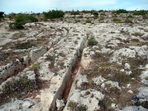
These early wagons had fixed axles steering was achieved by physical force applied to the side of the wagon (2-wheeled carts and chariots were developed quite a bit later and were linked to the domestication of the horse). As the use of heavy wagons became more commonplace, it seems that where a relatively soft, flat bedrock was close to the surface, wheel ruts started to be worn into the surface, and people found the ruts made guiding their cart easier, the wheels just followed in the groves. From this starting point, it does not need a huge leap of imagination for someone to realize that by carving a starting point into the rock, subsequent use would develop deeper grooves though wear, making the job of guiding a cart progressively easier. This type of ‘cart rut’, can be found in Malta, Greece, Italy, Sicily, Sardinia, Switzerland, Spain, Cyrenaica, Portugal, Azerbaijan and France.
As with most examples, the age and purpose of the Maltese tracks is uncertain with estimates of their origins ranging from c.700 BCE, but with several examples pointing to a Temple Period date c. 3800-2500 BCE. The underlying rock in Malta is weak and when it’s wet it loses about 80 percent of its strength so whether these tracks were carved, or worn into the bedrock, or started by carving then worn deeper, is open to question.
Misrah Ghar il-Kbir (Clapham Junction) – Malta.
These earlier examples suggests the convenience of having guides to help keep carts on the desired track would have been well understood by the time the Diolkos was built. The builders of the Diolkos simply expanded on the concept by making their own ‘bedrock’ by laying paving stones.
The use of fixed (non-steering) axles continues through to the present time. The mine carts of the 13th century, the ‘chaldrons’ used on the NE England wagonways in the 18th century to move coal to the wharfs, through to modern railway freight cars all use fixed axles guided by groves or rails. For more on the history of railways see the papers at: https://mosaicprojects.com.au/PMKI-ZSY-005.php#Process2.
The use of a steerable front axle on wagons is a much later development, dependent on the availability of iron to efficiently manage the high loads at the pivot pin. This was achieved in about 500 B.C. (although some commentators put the date as early as 1500 B.C.) with the production of an axle capable of swiveling about a vertical axis. Such vehicles can be readily detected in accurate drawings because the front wheels had to be small enough in diameter to pass under the floor of the vehicle. The technology did not spread rapidly. There were only a few steerable wagons in fourteenth-century England, and they were not widespread until the seventeenth century.
Most people own some land and they, and many projects, need to accurately locate the position of their property lines and facilities, but achieving this is far from straightforward.
One reasonably well-known example of this challenge is the Prime Meridian at Greenwich. This historic meridian is a geographical reference line that is marked on the ground, and passes through the Royal Observatory, in Greenwich, London (the dashed line above). But, the Prime Meridian used by your GPS is the solid line 102 meters to the east. The objective of our latest article is to explain why these are different! It is a long story starting in the third century BCE, that intertwines astronomy, map making, navigation, and time keeping.
Scientific understanding of the shape of the earth has changed from the Ancient Greek assumption it was a sphere, to the modern understanding the earth is a shape-shifting mass that approximates an oblate spheroid. This shift in understanding does not change the relationship between latitude, longitude, and time, but the relentless changes in the earths surfaces do continue to affect map making and surveying. Sometimes the change can be catastrophic – this tree was split in two by the Türkiye Earthquake*. But fortunately, most of the time both the magnitude and rate of change are quite small, but for many applications cannot be ignored.
So, answering the question ‘where in the world are you?’ accurately can be remarkably difficult and will change over time. To find out why download our article:Knowing (exactly) where you are is not that simple!
*To do something to help your career, and the Türkiye Earthquake victims, join PM 4 The World for a 24 hour ‘talk around the clock’ webinar bringing together many leading project management practitioners. All donations go straight to UNICEF: https://talk-around-the-clock.com/event-schedule